

Crossing Borders: Boundary Waters to Quetico | Part Three
I'm currently planning a winter camping adventure that starts in the Boundary Waters Canoe Area Wilderness (BWCA) in northern Minnesota and heads up into Quetico Provincial Park in Canada. Over the next few weeks, I'll be sharing some of the ways that I'll be preparing for this. I hope that it will be informative and inspire you as you plan your adventures. Sound good? Great. Here we go...
Part Three
Missed Parts One and Two? Start here.
WEATHER
People usually think of safety and warmth first when considering a winter adventure. As a wilderness guide, the most common comments I get are “How do you stay warm?” or “Do you worry about the ice?” Weather, ice quality, and safety all rule when traveling to remote locations. As a result, I will spend time over the next few weeks watching the trends.
Having grown up in the upper Midwest helps. I’m familiar with sub-zero temps, blizzards, and blustery wind. Deciding to camp in it is another matter and requires more skills.
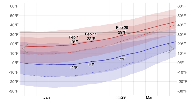
Average temps for February in Ely, Minnesota, which is the nearest town to our entry point, range from 19º for the high and -2º for the low. Our trip will take place in early February.
What does this mean for us? Well, it’s been an above-average season. December was warm in the north; there were even a few days of rain. Now, at the beginning of January, folks are reporting 5-8” of ice on the lakes with small pockets of open water on some lakes (usually in bays or along the edges). The next week is supposed to be colder which will allow for continued ice formation. I’m feeling confident we’ll have solid, thick ice.


Finally, there are only modest amounts of snow being reported up north. This makes lake travel relatively easy, but not ideal for dragging sleds over portage trails. In the end, we could still get a decent amount of snow in the next few weeks before we go.
My go-to will be to follow NOAA for the forecast until we leave as I’ve found it to be the most reliable source as a wilderness adventurer. On the trail, I’ll carry my Garmin InReach which is essential in case of an emergency but also allows me to request current weather forecasts for my exact location.
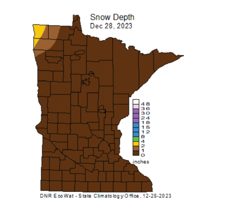
source (note: MN DNR is delaying early Jan report)

This is promising but we need more ice development before a ton of snow falls.
ICE SAFETY
For this journey, we’ll be crossing both large and small bodies of water, including a couple of creeks. Our route includes 17 lakes and 14 portages, give or take. Now that I’ve got the weather in my sights, my mind goes to ice.
The Minnesota DNR doesn’t officially measure ice thickness however, they provide a graphic for determining when ice is safe depending on activity. For our needs, we need at least 4'“ minimum thickness as we’ll be on skis (or foot!) pulling sleds.
How can we know if ice is safe? Well, we can’t ever be 100% sure, but we have some tools and strategies when it comes to determining ice safety and conditions.
First, I’ll check with the forest station, outfitters, and other guides for current conditions on various lakes. Our kit will include an ice chisel. We can use it to chop and determine ice thickness as we go. Secondly, we’ll scan the ice, avoiding patches of gray or yellowing snow, and of course open water. Even in sub-zero temps, there will be spots of open water, usually around moving water. This means we’ll need to be careful around areas such as river or waterfall inlets and outlets. Pinch points where bodies of land come close together to create a channel will be on our radar. There are likely underwater currents in these areas, creating thinner ice between larger bodies of water.
For added safety, I’ll wear ice picks and carry a throw bag in the event of an immersion. Emergency gear will be kept close at hand as well.

Example of a pinch point.


Mid-March ice one trip was still 12-18” thick but it was deteriorating. We got up early on the last day to travel when it was colder and before it hit the anticipated 45º!
After researching conditions, getting up-to-date reports, and assessing the ice ourselves, we’ll go with our gut. If it doesn’t look or feel right, we’ll move to another place.
GEAR & PACKING
Yay! We’re onto more of the fun stuff. I like talking about gear. We plan to travel like a winter backpacker, but with lightweight sleds connected to harnesses. As always, this will depend on conditions and temps. There is a Plan B in place if it all goes to heck.
We have two individuals and one couple in our group. Everyone has various shelter and sleep systems. I’ll share more about that later. The hope is to pack safely and comfortably, but lighter so that we can do more miles and get deeper into the wilderness.
You’re welcome to check out my current packing list. I’ve included some brands and styles, but keep in mind that stuff is likely to change and adapt as we get closer to our trip. In a couple of weeks, I’ll go do a two-night camping trip at a local state park with my gear and finalize what I plan to bring. This also gives me a chance to make sure everything is in good, working order.
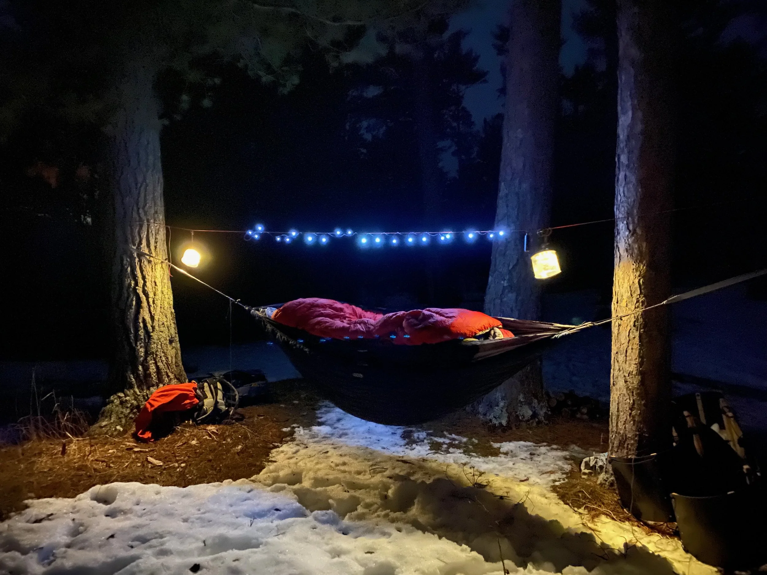
Mild temps allowed for skipping a tarp (though I had one). Temps averaged 25º at night with no wind.
SLEEP & SHELTER
We all have varied shelter and sleep systems. I’m planning on either sleeping on the ice, cowboy camping, or on land under a tarp or hammock. It will depend on the conditions and my preferences closer to the trip. That said, I’ll bring a solid enough shelter system in case of unexpected weather.
I have a few different tarps to choose from, but unless we decide to hammock, I suspect we’ll bring our 10’x12’ tarp, a waxed canvas ground cloth, and share it. Otherwise, we have a couple of mid-range hammocks that we can nest with top and under quilts, protected by tarps.
My sleep system will be similar for all situations which means a combo of closed-cell foam pads, insulated inflatable pads, sleeping bag liners, and sleeping bags (or quilts) with possible overbags rated to at least -20º. The final configuration won’t be decided until we’re closer to the trip.
When I guide winter trips, I sleep outside, usually in a hammock as I find it most comfortable and warm. But I’ve had a few experiences sleeping out on the ice and that can be fun too–especially when the stars are out. Usually, it’s warmer to sleep higher up, on land, and back in the woods where you’re protected from the elements. Sometimes the nights are mild though, and we’re drawn out onto the ice.
As you can see, I don’t have this figured out yet. It seems like with most winter trips, my systems must adapt to anticipated weather conditions, length of travel days, style of winter camping, and personal preference. If you’ve done some winter camping, maybe this sounds familiar.
Next up! Time to plan and prepare for the shakeout weekend. I can’t wait!
Head to Part Four.
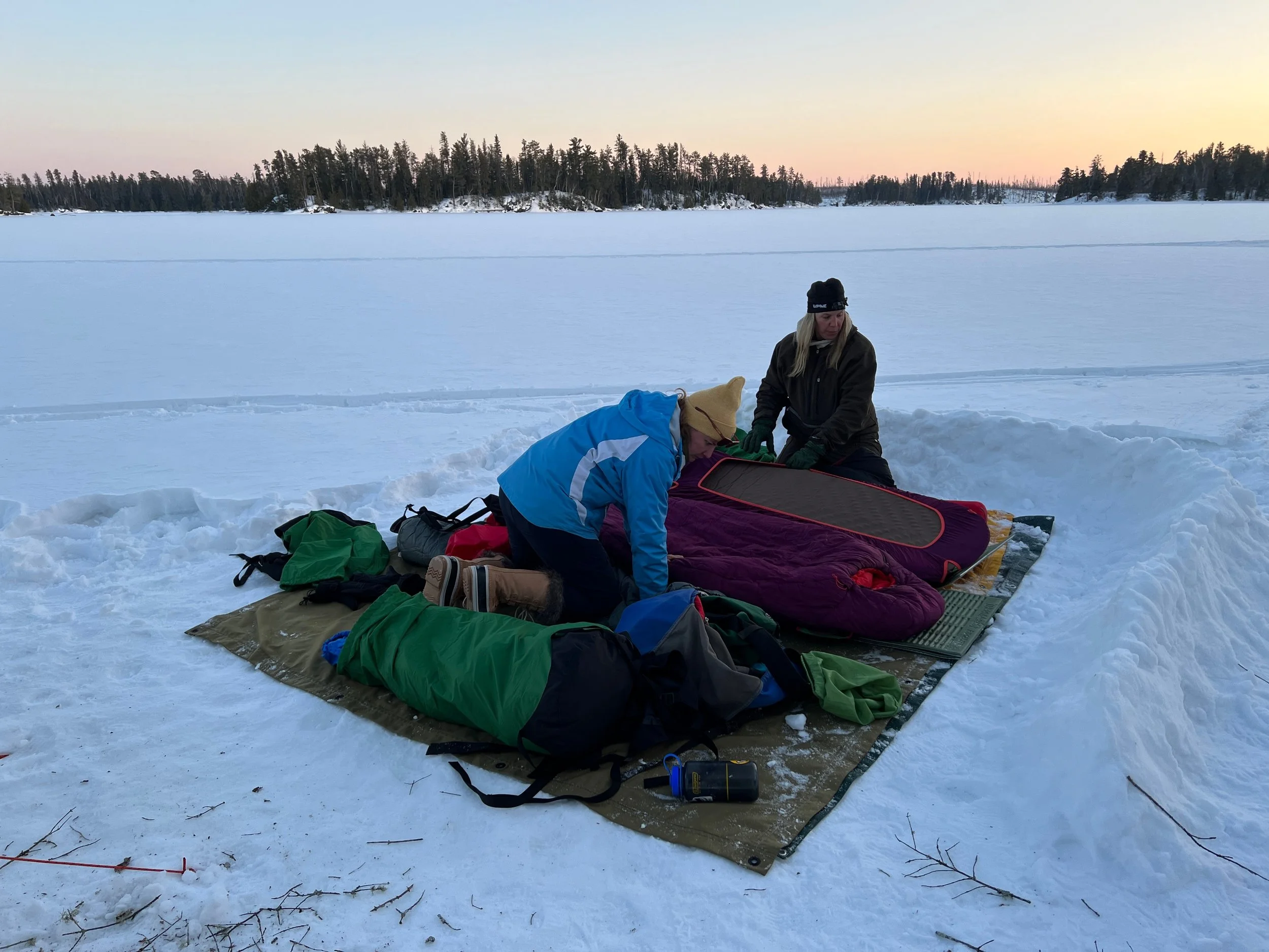
Preparing to sleep on the ice during mild weather. Temps went down to 15º at night with a 5 mph breeze. We were in a protected bay out of the wind, however we built a wind wall (seen on the right) in case it kicked up. Sleeping bags were rated to -20º and included outer bags.
Disclaimer: Winter adventures can be dangerous. It’s up to you to plan and prepare for all the conditions you may encounter. Honestly assess your experiences, fitness, and skill set. The BWCA and Quetico are remote wilderness areas and help may be hours or a day away. Conditions change frequently. Check with local outfitters and forest stations for current updates. Information stated in this article may be inaccurate and/or not up to date.
Advertising
As an Amazon Associate, I earn a small commission from qualifying purchases at no cost to you. I recommend products I’ve used myself and found to be reliable.